Friday, September 25, 2015

Monthly Favorite Surprise RR * July '15

Last July I joined this great RR. The idea is to send cards (1 card minimum, 8 cards maximum) according to the receivers favorites or wishlists. I've already joined 3 times and I always send 4 cards, in return I get the same number of cards but I don't know who'll send them. So far, i've only got nice cards. These are the 1st four I got, from Germany, Netherlands, France and Ireland. 

I've already sent a couple of cards to Antje, tags, but this was the 1st card I got from her. This is the Old Bridge in Jena, built in 1534. It was destroyed during the Thirty Years War (1637), reconstructed in 1706 and received its present appearance in 1744 . During World War II on April 12, 1945, a few arches were damaged. The reconstruction started in 2001 and was completed in 2004.

© The online postcard shop
Marina sent me this beautiful card of the Heeswijk Castle, located near Heeswijk in the North Brabant province of the Netherlands. The castle was originally constructed during the 11th century and was later restored in 2005. A motte was first erected in 1080, but would be reduced over the next few centuries. A castle would eventually be built in its place.
Heeswijk Castle was an integral part of the history of the Netherlands. Prince Mauritis failed twice to take over Heeswijk in 1600. His half-brother Frederick Henry, however, did succeed in 1629. This allowed him to attack ‘s-Hertogenbosch.
In 1649, the castle was transformed into a baroque residence and lost its defensive features. In 1672, Louis XIV stayed at Heeswijk while campaigning against the Dutch Republic. King Charles II of England as well as the bishops of Munster and Cologne visited the castle to sign the Treaty of Heeswijk.
General Pichegru, who was under Napolean’s command, used the castle as a headquarters in the late 18th century. In the early 1800s, the castle was purchased by Andre Baron van den Bogaerde van Terbrugge. However, by this time, the castle had already fallen into a state of disrepair. Reconstruction began and the castle was then expanded to include an armory. The “Iron Tower” was also constructed and served as a place to store his son’s collection of art and curiosa.
Surprisingly, the castle only suffered minimal damage during World War II. In 1944, the parachutists of the 101st Airborne Division actually landed around Heeswijk Castle. - in: http://www.netherlands-tourism.com/heeswijk-castle/

Photo: Marc-Olivier Sicard
Another castle, this one from France, sent by Nathalie. 
Unusually among the historical castles of France, Rambouillet plays a role as important now as it did in the past - it is now the summer residence for French presidents, and frequent host to heads of state from other countries.
Dating from the 14th century, at which time it was a manor house, it gained importance as an occasional royal residence, and it was here that King Francois I died in 1547.
The castle retains a medieval defensive form, with turrets in each corner of the building, although the castle has been very extensively altered during the follwoing centuries.
The extensive gardens and parkland that surround the castle were laid out during the first half of the 17th century - the castle is surrounded by 200 square kilometres of land, much of it covered by ancient forests. The garden is significantly more 'English' in style than many of the castles in the Paris region and the Loire Valley.
Towards the end of the 18th century the castle passed to the crown under Louis XVI, bought as a gift for Marie Antoinette. It's political importance continued into the 19th century - Napoleon occasionally stayed here, and his 'successor' King Charles X, abdicated at the castle.
It is from the end of the 19th century that Rambouillet has acted as the official French Presidential summer residence.
During the 20th century many important meetings and summits have been held here. General de Gaulle frequently held important receptions at the castle. More recent engagements have included the G6 meetings of leading industrialised nations, Kosovo peace agreement discussions, and state visits by Boris Yeltsin and Nelson Mandela. - in: http://www.castles.francethisway.com/chateau-rambouillet.php

Photography reproduced from original artistic work © Liam Blake
And the last card of the July's RR came from Ireland, sent by John. In a few weeks, 4, I'll visit Trinity College in Dublin. 
Trinity College, known in full as the College of the Holy and Undivided Trinity of Queen Elizabeth near Dublin, is a research university and the sole constituent college of the University of Dublin in Ireland. The college was founded in 1592 as the "mother" of a new university,[Note 1] modelled after the collegiate universities of Oxford and of Cambridge, but, unlike these, only one college was ever established; as such, the designations "Trinity College" and "University of Dublin" are usually synonymous for practical purposes. It is one of the seven ancient universities of Britain and Ireland, as well as Ireland's oldest university. - in: wikipedia

Thursday, September 24, 2015

US-3529534, US-3529533 & US-3427335

Officals from Iowa, Indiana and Washington in the United States. 

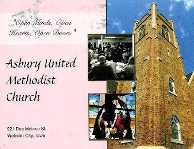
US-3529534, sent by Abby.
Asbury United Methodist Church in Webster City, built between 1911 and 1912.  

Photos: Kim White
US-3529533, sent by Natalya.
Potter's Bridge Park features the only remaining covered bridge in Hamilton County, and is surrounded by a 66-acre park. Constructed between 1870-1871 by Josiah Durfee, and restored in 1999, the bridge serves as the centerpiece of Potter's Bridge Park. The bridge boasts beautiful views of the White River and is a great place to observe wildlife in its natural habitat. - in: http://www.visithamiltoncounty.com/listings/Potter-s-Bridge-Park/1678/242/
The bridge was listed on the National Register of Historic Places in 1991 and in 1999 Potter's Bridge Park was opened. 

Photo © James P. Rowan
US-3427335, sent by Colleen.
Cape Flattery is northwesternmost point in the continental United States. Here, where the Strait of Juan de Fuca meets the Pacific, Cape Flattery protrudes into a sea of tumultuous waters. A land of dramatic headlands, sea stacks, and deep narrow coves, Cape Flattery exhibits sheer rugged beauty. Scores of seabirds ride the surf and scavenge the sea stacks. Watch for whales and sea lions too. - in: http://www.wta.org/go-hiking/hikes/cape-flattery 

Wednesday, September 23, 2015

Zion National Park - USA

Zion National Park is both the oldest and the oldest national park in Utah. It was the state’s first federally designated park (1919). It’s also Utah’s most visited national park, drawing more than 3 million visitors annually. The park is known for its slot canyons, towers and monoliths, rivers and waterfalls, and scenic sandstone.
The card was sent by "wayness".

Photo: John Wagner
On the back of the card: The Watchman, a monolith of Navajo sandstone, is a prominent landmark near the mouth of Zion Canyon in Zion National Park. Protected within the parks's 229 square miles is a dramatic landscape of sculptured canyons and soaring cliffs. This unique geography and the variety of the life zones within the park, make Zion significant as a place of unusual plant and aninal diversity. 

Monarch Butterfly Biosphere Reserve - Mexico

5th and last card sent by Marco. Now I've 20 of the 32 mexican UNESCO sites. The Monarch Butterfly Biosphere Reserve was added to the WHS list in 2008. 

Foto: Encar
The 56,259 ha biosphere lies within rugged forested mountains about 100 km northwest of Mexico City. Every autumn, millions, perhaps a billion, butterflies from wide areas of North America return to the site and cluster on small areas of the forest reserve, colouring its trees orange and literally bending their branches under their collective weight. In the spring, these butterflies begin an 8 month migration that takes them all the way to Eastern Canada and back, during which time four successive generations are born and die. How they find their way back to their overwintering site remains a mystery. - in: http://whc.unesco.org/en/list/1290

Friday, September 18, 2015

Cabo San Lucas - Mexico

Cabo San Lucas is one of the areas classified and identified on the UNESCO list as Islands and Protected Areas of the Gulf of California. The site was classified in 2005 and comprises 244 islands, islets and coastal areas that are located in the Gulf of California in north-eastern Mexico. 
This 4th card sent by Marco shows the Arch of San Lucas, the exact place where the Pacific Ocean becomes the Gulf of California, also known as Sea of Cortez.

The Sea of Cortez and its islands have been called a natural laboratory for the investigation of speciation. Moreover, almost all major oceanographic processes occurring in the planet’s oceans are present in the property, giving it extraordinary importance for study. The site is one of striking natural beauty in a dramatic setting formed by rugged islands with high cliffs and sandy beaches, which contrast with the brilliant reflection from the desert and the surrounding turquoise waters. - in: http://whc.unesco.org/en/list/1182

© Claude Vogel
The distinctive landmark of Cabo San Lucas is the rugged taffy-colored El Arco (The Arch) rock formation that erupts from the sea at the tip of the Baja Peninsula. the arch is also known as Land's End because, as the crow flies, if you followed a line south from here, you would not touch land again until you reached the South Pole.

Thursday, September 17, 2015

Morelia - Mexico

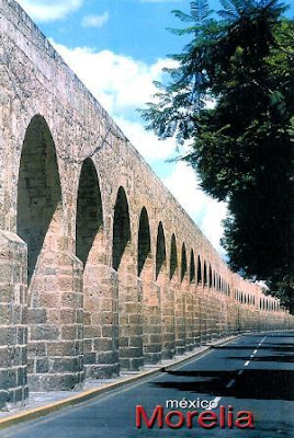
Here it comes the 3rd mexican card sent by Marco. The Historic Center of Morelia was classified as UNESCO WHS in 1991.

Built in the 16th century, Morelia is an outstanding example of urban planning which combines the ideas of the Spanish Renaissance with the Mesoamerican experience. Well-adapted to the slopes of the hill site, its streets still follow the original layout. More than 200 historic buildings, all in the region's characteristic pink stone, reflect the town's architectural history, revealing a masterly and eclectic blend of the medieval spirit with Renaissance, Baroque and neoclassical elements. Morelia was the birthplace of several important personalities of independent Mexico and has played a major role in the country's history. - in: http://whc.unesco.org/en/list/585

This beautiful aqueduct of quarry pink, measure 1810 meters and consists of 253 arches and two boxes of water. 
Construction take us to the days of the golden age of the former Valladolid. In 1785 Bishop Fray Antonio de San Miguel commanded  to built an aqueduct with two purposes: to bring drinking water to the city which was hit by a terrible drought for two years and to provide work for the indigenous people of the region. The stone was transported from the village of Santa María (now part of the city) and goes to the old Calle Real. Today, Madero avenue. - in: http://www.travelbymexico.com/morelia/atractivos/index2.php?nom=bmoracueducto

Tuesday, September 15, 2015

Querétaro - Mexico

The 2nd card sent by Marco was from Querétaro, the capital capital and largest city of the state of Querétaro, located in central Mexico.

© www.exploworld.com
The city has preserved its historic downtown and taken steps to beautify many areas. The Historic Monuments Zone of Queretaro was named a UNESCO World Heritage site in 1996. The property was inscribed on the basis of two of its cultural criteria and considering that the site is of outstanding universal value and an exceptional example of a colonial town whose layout symbolizes its multiethnic population. It is also endowed with a wealth of outstanding buildings, notably from the 17th and 18th centuries.
Queretaro holds several treasures, and a friendly sense of civic pride prevails. The historic city center is filled with lovely colonial mansions, immaculate pedestrian  alkways (andadores) and quaint plazas little changed since colonial days. - in: http://www.visitmexico.com/en/queretaro

Monday, September 14, 2015

San Miguel de Allende - Mexico

Some time ago Marco, a mexican living in Austria, asked me if I could get some portuguese stamps and souvenir sheets. I didn't find any of his wishes in my local post office but I managed to get waht he wanted online. In return I got 5 of my missing mexican UNESCO sites. I couldn't be happier. 
Lets start with a card from San Miguel de Allende. 

Located in Guanajuato state, 265 km (165 miles) northeast of Mexico City and 96 km (60 miles) from the state capital, Guanajuato city, San Miguel is located within Mexico's hilly central highlands.
Once an important stop on the silver route between Zacatecas and Mexico City, its historic center is filled with well-preserved buildings from the 17th and 18th centuries. With its narrow cobblestone streets, leafy courtyards, fine architectural details and sumptuous interiors, San Miguel de Allende is arguably the prettiest town in Mexico.
In 2008 UNESCO recognized San Miguel de Allende and the neighboring Sanctuary of Jesus de Atotonilco as World Heritage of Humanity sites, citing the town's religious and civil architecture as a demonstration of the evolution of different trends and styles, from Baroque to late 19th century Neo-Gothic. - in: http://www.visitmexico.com/en/san-miguel-de-allende

Fotografia: Jüpgen Bavoni * Diseño: G. Escobedo
La Parroquia de San Miguel Arcángel, the current parish church of San Miguel, is unique in Mexico and the emblem of the town. It has a Neo-gothic façade with two tall towers that can be seen from most parts of town. It is one of the most photographed churches in Mexico. The church was built in the 17th century with a traditional Mexican façade. The current Gothic façade was constructed in 1880 by Zeferino Gutierrez, who was an indigenous bricklayer and self-taught architect. It is said Gutierrez's inspiration came from postcards and lithographs of Gothic churches in Europe; however, the interpretation is his own and if more a work of imagination than a faithful reconstruction. - in: wikipedia

Thursday, September 10, 2015

Emerald Lakes - New Zealand

Lets keep with volcanoes with a beautiful volcanic scenary in Tongariro Alpine Crossing, New Zealand’s most popular one day hike in Tongariro National Park. 
This beautiful card was sent by Adrienne. 

Photo © Edward Shaw
On the back of the card: Crossing spectacular volcanic terrain in the presence of two active volcanoes helps to make the Tongariro Crossing one of the best day walks in New Zealand. The water filled explosion craters, known as Emerald Lakes, get their brilliant greenish colour from the minerals which have leached from the adjoining thermal area. 

Bromo Tengger Semeru N. P. - Indonesia

The 1st of these card is an official from Czech Republic but the card is actually from Bromo Tengger Semeru National Park in Indonesia. I already had a card from there, sent 5 years ago by Shinta. 

© mauritius images/Alamy
CZ-654836, sent by Homer
The Bromo Tengger Semeru National Park covers a massive area of 800 square kilometres in the centre of East Java. For anyone with an interest in volcanoes, a visit to the park is a must. This is the largest volcanic region in the province. Visit the park and see the plumes of smoke coming from Mt. Semeru, an active volcano which rises 3676 meters above sea level. Experience the remarkable Tengger Caldera, Java's largest, with its 10 km barren desert-like sea of sand. Within the caldera rise the deeply fissured volcanic cones of Batok and Bromo, the latter is still active with a cavernous crater from which smoke blows skyward. 

Temperatures at the top of Mount Bromo range about 5 to 18 degrees Celsius. To the south of the park is a rolling upland plateau dissected by valleys and dotted with several small scenic lakes, extending to the foot of Mount Semeru. 
The Tengger sandy area has been protected since 1919. This is believed to be the only conservation area in Indonesia, and possibly the world which possesses a unique sand sea at the attitude of about 2000 m above sea level. There are several mountains inside the caldera: Mt Watangan (2,661 m asl). Mt Batok (2,470 m asl), Mt Kursi (2,581 asl), Mt Watangan (2,661 m asl), and Mt Widadaren (2,650 m asl).
With beautiful scenery, easy access and visitor-oriented facilities, it’s no wonder that this one of the most popular reserves in Java. - in: http://www.indonesia.travel/en/destination/319/bromo-tengger-semeru-national-park

Thaipusam Festival - Malaysia

A few months ago Bei Hao asked me to swap cards and I got this one in return. 
All those people are celebrating Thaipusam Festival, which is celebrated in two places in Malaysia, that's in the Batu Caves in Kuala Lumpur and on Penang.
Thaipusam is an Indian festival. It's a celebration for the son of Shiva (Murugan also known as Subramaniam) and the becoming "one" of  Pusan and the Brihaspati stars. Lord Murugan is the universal granter of wishes.  All those who wish to ask for a future favour, fulfil a vow in return for a granted favour, or to repent for past sins will participate in this festival. - in: http://www.malaysiasite.nl/thaipusameng.htm

The festival is held in the tenth month of the Hindu calendar (mostly the end of January).
The temple at Batu Caves, near Kuala Lumpur, often attracts over one million devotees and tens of thousands of tourists. The procession to the caves starts at the Sri Mahamariamman Temple, Kuala Lumpur in the heart of the city and proceeds for 15 kilometres to the caves, an 8-hour journey culminating in a flight of 272 steps to the top. Devotees carry containers containing milk as offering to Lord Murugan either by hand or in huge decorated carriers on their shoulders called 'kavadi'. The kavadi may be simple wooden arched semi-circular supports holding a carrier foisted with brass or clay pots of milk or huge, heavy ones which may rise up to two metres, built of bowed metal frames which hold long skewers, the sharpened end of which pierce the skin of the bearers torso. The kavadi is decorated with flowers and peacock feathers imported from India. Some kavadi may weigh as much as a hundred kilograms. After bathing in the nearby Sungei Batu (Rocky River), the devotees make their way to the Temple Cave and climb the flights of stairs to the temple in the cave. Devotees use the wider centre staircase while worshippers and onlookers throng up and down those balustrades on either side. When the kavadi bearer arrives at the foot of the 272-step stairway leading up to the Temple Cave, the devotee has to make the arduous climb. Priests attend to the kavadi bearers. Consecrated ash is sprinkled over the hooks and skewers piercing the devotees' flesh before they are removed. No blood is shed during the piercing and removal. - in: wikipedia

Tuesday, September 8, 2015

Bayon Temple - Cambodia

Ara's asian trip also included a visit to Cambodia. Incredible was the word she used to describe this country.
She sent me my 3rd card of the Bayon Temple. The others were sent by Mian back in 2008 and by Aarati as an indonesian official card last year.  
Photo © The Corner Art Photography, Cambodia
"Bayon Temple is the spectacular central temple of the ancient city of Angkor Thom, which is located just to the north of the famous Angkor Wat in Angkor, Cambodia.
Angkor Thom was built as a square, the sides of which run exactly north to south and east to west. Standing in the exact center of the walled city, Bayon Temple represents the intersection of heaven and earth. Built around 1190 AD by King Jayavarman VII, Bayon is a Buddhist temple but it incorporates elements of Hindu cosmology.

Bayon is known for its huge stone faces of the bodhisattva Avalokiteshvara, with one facing outward and keeping watch at each compass point. The curious smiling image, thought by many to be a portrait of Jayavarman himself, has been dubbed by some the "Mona Lisa of Southeast Asia." There are 51 smaller towers surrounding Bayon, each with four faces of its own.

ID-118232, sent by Aarati
Bayon Temple is surrounded by two long walls bearing an extraordinary collection of bas-relief scenes of legendary and historical events. In all, there are are total of more than 11,000 carved figures over 1.2km of wall. They were probably originally painted and gilded, but this has long since faded." - in: http://www.sacred-destinations.com/cambodia/angkor-thom-bayon-temple

Sa Pa - Vietnam

I'm back from my holidays. Is not that I don't mind but I didn't travel to such an exotic country as Ara did last may. She said the Vietnam's landscapes are beautiful and its people very friendly. Maybe one day I can confirm that.

Photo: Toan Huynh
Sa Pa is a frontier town and capital of Sa Pa District in Lào Cai Province in northwest Vietnam. 
Growing rice, Vietnam's most important crop on hillside terraces, is one of the most characteristic activities of Sa Pa.