Thursday, May 30, 2013

Cangas de Onis - Spain

This bridge over the Sella River is one of the best-known symbols of the Principality of Asturias, in northern Spain.
The card was sent by Zé Pombal.

© FISA - Escudo de Oro S. A.
Although this site may have been used in Roman times to cross the Sella River, and this may have been the reason for the foundation of Cangas de Onís, the first capital of the Kingdom of Asturias, in fact the current "Roman Bridge” dates to mediaeval times, possibly to the end of the 13th century.
Its stylised and graceful outline, and the line of the arches take us back to a Romanesque style in transition to Gothic. It has three slightly pointed arches. The central, under which the river flows, is by far the biggest and is cambered. The two on each side are of different sizes.
From the central arch hangs a reproduction of the famous Victory Cross, a work of precious metal dating to the start of the 10th century that is kept in Oviedo Cathedral. - in:
 http://www.spain.info/en/conoce/monumentos/asturias/puente_sobre_el_rio_sella.html

Monday, May 27, 2013

Ourense - Spain

On Mother's Day (1st sunday of May in Portugal) Vitória made one of her mom's dream come true, to visit Santiago de Compostela. It was a lovely present, wasn't it? After Santiago they visited Ourense and Vitória sent me this lovely card of the local cathedral.

© Ediciones Paris S. L.
The cathedral is the most important monument in Ourense. This cathedral (founded 572; rebuilt in the 13th century) is the second oldest in Galicia. It occupies the same site as the Suevian basilica that stood there in earlier times. Romanesque in structure, but with a mixture of Romanesque and Gothic styles, it is rather hidden away but, contains a façade with the Door of Paradise in imitation of the Door of Glory of the Cathedral of Santiago de Compostela. Inside, the Capilla del Cristo, or Christ's Chapel (16th century), contains a crucifix venerated throughout Galicia. - in: wikipedia

Santiago de Compostela - Spain

Santiago de Compostela is the spanish city on the top of my must visit list. I'd love to visit it but unfortunately i think this won't happen anytime soon.
This card was sent by Margarida.

Santiago de Compostela  is the capital of the autonomous community of Galicia in northwestern Spain.
The city has its origin in the shrine of Saint James the Great, now the city's cathedral, as destination of the Way of St. James, a leading Catholic pilgrimage route originated in the 9th century. In 1985 the city's Old Town was designated a UNESCO World Heritage Site.

Ediciones Arribas
Santiago de Compostela Cathedral  is the reputed burial-place of Saint James the Greater, one of the apostles of Jesus Christ. The building is a Romanesque structure with later Gothic and Baroque additions.
According to legend, the apostle Saint James the Greater brought Christianity to the Celts in the Iberian Peninsula. In 44 AD he was beheaded in Jerusalem. His remains were later brought back to Galicia, Spain. Following Roman persecutions of Spanish Christians, his tomb was abandoned in the 3rd century. Still according to legend, this tomb was rediscovered in 814 AD by the hermit Pelagius, after witnessing strange lights in the night sky. Bishop Theodomirus of Iria recognized this as a miracle and informed king Alfonso II of Asturias and Galicia (791-842). The king ordered the construction of a chapel on the site. Legend has it that the king became the first pilgrim to this shrine. This was followed by a first church in 829 AD and again in 899 AD by a pre-Romanesque church, at the order of king Alfonso III of León, causing the gradual development of a major place of pilgrimage.
Construction of the present cathedral began in 1075 under the reign of Alfonso VI of Castile (1040–1109). Construction was halted several times and, according to the Liber Sancti Iacobi, the last stone was laid in 1122. But by then, the construction of the cathedral was certainly not finished. The cathedral was consecrated in 1128 in the presence of king Alfonso IX of Leon. - in: wikipedia

Friday, May 24, 2013

Vasco da Gama Street, Guarda - Portugal

This is an old card from my city. I didn't recognized immediately the place even if nowadays it doesn't look much different.

The biggest differences are the balconies of the hotel on the corner, they're aren't so colorful now, and the blue house by the end of the street doesn't exist anymore. On the same place of the blue house there's a 5 or 6 story building.
The card was sent by Gracinha.

Thursday, May 23, 2013

Sunset in Algarve

This card is another prize from another game in the portuguese community.

Photo by César de Sá
This sunset card in Algarve was sent by José.

A cork postcard

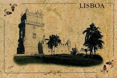
Edite is a new member in the portuguese postcrossing community. I guessed her hangman's game sentence and she sent me this cork postcard of the Belém Tower in Lisbon. This is my 2nd cork postcard.
Portugal is the premier producer of cork in the world and it accounts for about 50% of the world’s total cork production.
It is to be noted that the growth of the cork oak tree is greatly influenced by environmental factors and the Mediterranean type climate of Portugal is conducive to its growth. Well distributed and plenty of rainfall together with presence of extensive sunshine, mild winter weather conditions and suitable soil compositions aid its growth in the country and the life span of cork oak trees extends to around 150 to 200 years. Algarve produces the superior quality in Portugal and certain species are also produced in the Alentejo region as well and it is in the central and southern parts that corks of the best quality are grown.

www.sofoto.pt | Foto: J. C. Pinheira
The Portuguese cork industry is highly developed and the versatility of cork as a substance together its ecological properties and the ability to recycle the material has facilitated its growth. Cork is used in performing multifarious functions like for building and architectural purposes and in floors, in the automobile, military and space industries, in footwear and leather goods, as chemical components in pharmaceutical industries and most importantly as cork stoppers used as closures for wine bottles. In Portugal, which is known for its wines and vineyards, it is doubtless that cork stoppers are extremely useful for domestic purposes. Cork wools are also used in mattresses and cushions.
It has been estimated that a whopping 16% of the total foreign income in Portugal is accumulated from the export of cork. The main importers of Portuguese cork are Germany, UK and USA. - in:  http://www.cork.pt/cork-industry-in-portugal.html

Regaleira Palace - Portugal

Adrienne Garry from New Zealand has been to Portugal a few weeks ago and she met a few portuguese postcrossers in Sintra. José sent me this card of the Regaleira Palace in Sintra, signed by him, Adrienne, Paula, Ninocas and her son, Joaninha and Rita Oliveira.

Rufino & Rufino, Lda
The Regaleira Palace and Estate, also known as also known as the "Palace of Monteiro the Millionaire”, was built in the beginning of the 20th century, born from the imagination of its millionaire owner António Augusto Carvalho Monteiro and the Italian architect Luigi Manini.
From dream to reality was born Regaleira Estate, a combination of several artistic and architectonical styles, from Gothic to Manueline, with a Renaissance touch. The result was an unique creation, filled with magical nooks and details that disclose the union between national History and esoteric and mythic interest, inevitably associated to the mountain range of Sintra.
From the luxuriant gardens to the numerous buildings, such as the Milhões Palace, the Santíssima Trindade Chapel, or the turrets and the small palaces, the Regaleira Estate provides an entrance in an alternative dimension that one could never guess just by looking at its main gate… - in:
http://guides.getportugal.com/lisbon/see/4919/11/regaleira-palace-and-estate

Monday, May 20, 2013

Montemor-o-Novo Castle - Portugal

This is one of the many castle in the Alentejo region. I've to Alentejo a few times in the last years but i didn't visit Montemor-o-Novo yet.

REUNIARTE
I've already posted a few cards of this castle, there's no need to add more information about it.
The card was sent by Vera.

Sunday, May 19, 2013

Deserta Grande - Madeira

From a portuguese archipelago to the other one. The Deserta Grande Island is the main island of the Desertas Islands, a small chain of islands in the archipelago of Madeira, located to the southeast of the island of Madeira. The island is a nature reserve.

Photo by H. Costa Neves
The card sent by Manú, shows the Nature Reserve wardens station located on Fajã da Doca and supports all the conservation work on the reserve.
Fajã means piece of fertile land consequence of a landslide and this one formed in 1984. It is now a natural harbour and the official anchorage of the reserve.

Joana's Peak - Terceira Island

I need peace and quiet; Azores are the perfect spot to take a rest. I'd love to visit these islands but this won't happen any time soon.
This very greenish card was sent by Lurdes.

Photo by Luís Godinho
Joana's Peak in located on the Feteira parish- The peak is a basaltic scoria volcanic cone, which is about 500 metres in diameter. The highest part of the cone reaches the 331 metres above sea level.

Saturday, May 18, 2013

Canadian Officials

Still in North America, now i've officials from Canada and 1 from the Netherlands but showing one of Canada's most famous lakes.

 Photo by Eero Sorila
CA-321048, sent by Richard.
The Capilano Suspension Bridge is a simple suspension bridge crossing the Capilano River in the District of North Vancouver, British Columbia, Canada. The current bridge is 140 metres (460 ft) long and 70 metres (230 ft) above the river. It is part of a private facility, with an admission fee, and draws over 800,000 visitors a year.
The bridge was originally built in 1889 by George Grant Mackay, a Scottish civil engineer and park commissioner for Vancouver. It was originally made of hemp ropes with a deck of cedar planks, and was replaced with a wire cable bridge in 1903. In 1910 Edward Mahon purchased the Capilano Suspension Bridge. "Mac" MacEachran purchased the Bridge from Mahon in 1935 and invited local natives to place their totem poles in the park, adding a native theme. In 1945, he sold the bridge to Henri Aubeneau.
The bridge was completely rebuilt in 1956. - in: wikipedia

 
© Published and Distributed exclusively by The Postcard Factory
CA-326603, sent by Rose
 The Forks is a historic site, meeting place and green space in Downtown Winnipeg located at the confluence ofthe Red River and Assiniboine River.
The Forks’ unique history is apparent in its bustling market. Originally two adjacent stables for competing rail companies circa early 1900, the horse stalls were joined together by a courtyard and bridges to create The Forks Market, Winnipeg’s incomparable shopping experience.
The Forks Market offers a multitude of shops to browse for a wide variety of specialty items and souvenirs. Downstairs, The Market features an irresistible fresh food emporium with everything from gourmet cheeses to meats organic baked goods and wine. Upstairs, in the Market Loft, shoppers will find items ranging from cigars and aromatherapy products to crafts and artworks from 300 local and Canadian artisans.
A constantly changing array of artisans and vendors also sell their wares at day tables inside The Forks Market and outside on The Plaza. - in: http://www.theforks.com/attractions/at-the-forks/the-forks-market

Photo by Tim Van Horn
 CA-332861, sent by Tara.
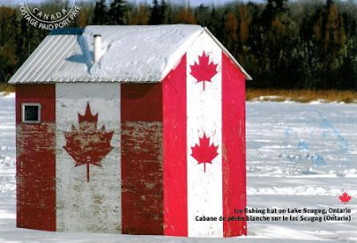
Ice fishing hut on Lake Scugog.
Lake Scugog, minutes from Toronto, is a man-made lake, the old river bed is remnant in the many buoys that mark the main channels. The lake is shallow and the waters are murky and very weedy. The dark waters are a perfect home for the elusive walleye.
In winter, lake Scugog becomes an ice fishing shanty town, with many areas targeted for both walleye and jumbo perch. Small pixie spoons and live minnows are both quite effective this time of year. The deeper areas of the lake in 15-17ft of water are your best bet for some ice fishing action. - in: http://www.thefishinguide.com/scugog.shtml

Friday, May 17, 2013

US-2136363

One more official from the US, this time from Texas.

Photo by LoneStarMike
US-2136363, sent by Dee Dee.
Austin  is the fourth-largest city and the capital of the U.S. state of Texas and the seat of Travis County. Located in Central Texas on the eastern edge of the American Southwest, Austin is the 13th most populous city in the United States of America and the fourth most populous city in the state of Texas.  Austin is also the third largest state capital in the United States after Phoenix and Indianapolis.
Austin is known as a "clean air city" for the city's stringent no-smoking ordinances that apply to all public places and buildings, and all restaurants. - in: wikipedia

American official cards

These are american officials, sent from different states of the US, Pennsylvania, Washington and Minnessota.  

  Photo © Thomas E. Walczak
US-2185668, sent by Julie.
On the back of the card: "The Logan Mills Covered Bridge, in Clinton County, Pennsylvania, spans the Fishing Creek in Loganton. Seen here in winter, the bridge was originally built in 1866, then rebuilt in 1979, and still allows traffic. Locals and tourists enjoy the charm and character of this lovely historic structure."

Photo by Laurel Mercury
US-2174496, sent by Brandy.
Located at the San Juan Islands, the Lime Kiln light, a name derived from the lime kilns built nearby in the 1860s, was first established in 1914. It was the last major light established in Washington. The lighthouse was updated five years later with a 38-foot octagonal concrete tower rising from the fog signal building. A fourth-order Fresnel lens was first exhibited from the new tower on June 30, 1919. The Coast Guard automated the Lime Kiln Lighthouse in August 1962, using photoelectric cells to turn the light on at dusk and off during daylight hours. In 1998, the drum lens was replaced with a modern optic, flashing a white light once every 10 seconds. Sitting on the rocky shoreline at a height of 55 feet, the beacon is visible for 17 miles. - in: wikipedia

US-2204964, sent by Sandra.
Split Rock Lighthouse is a lighthouse located southwest of Silver Bay, Minnesota, USA on the North Shore of Lake Superior. The structure was designed by lighthouse engineer Ralph Russell Tinkham and was completed in 1910 by the United States Lighthouse Service at a cost of $75,000, including the buildings and the land. It was built in response to the loss of ships during the famous Mataafa Storm of 1905, in which 29 ships were lost on Lake Superior. One of these shipwrecks, the Madeira, is located just north of the lighthouse. The light was first lit on July 31, 1910. - in: wikipedia

Wednesday, May 15, 2013

DE-1971526 & NL-1811846

These are officials from Germany and the Netherlands but the cards are both from California in the USA.

Photography © 1995 Carol Simowitz
 DE-1971526, sent by Sabine.
This card shows the Cliff House Restaurant on the western side of San Francisco, California. Cliff House is one of the most iconic restaurants in San Francisco.
Cliff House has had five major incarnations since its beginnings in 1858.

© by artcolor - photo by Roland Gerth
NL-1811846, sent by Irma.
An image of one of the many lakes in California.

Mexican Unesco cards

I'm so glad i got these cards. Both are new Unesco WHS from Mexico. The Mexico Unesco list is so big that every single card from there is very appreciated.
Historic Centre of Oaxaca and Archaeological Site of Monte Albán was inscribed in 1987 and the Archaeological Zone of Paquimé, Casas Grandes in 1998.

 Photo by A & P Giberstein
Monte Albán is a large pre-Columbian archaeological site in the Santa Cruz Xoxocotlán Municipality in the southern Mexican state of Oaxaca.
Monte Albán is an outstanding example of a pre-Columbian ceremonial centre in the middle zone of present-day Mexico, which was subjected to influences from the north - first from Teotihuacan, later the Aztecs - and from the south, the Maya. With its pelota court, magnificent temples, tombs and bas-reliefs with hieroglyphic inscriptions, Monte Albán bears unique testimony to the successive civilizations occupying the region during the pre-Classic and Classic periods. For more than a millennium, it exerted considerable influence on the whole cultural area. Latter-day Oaxaca is a perfect example of a 16th-century colonial town. Its monumental heritage is one of the richest and most coherent in the area that was known as New Spain. - in: http://whc.unesco.org/en/list/415

© Published and distributed by Tarjetas Sonora
Casas Grandes is the contemporary name given to a pre-Columbian archaeological zone and its central site, located in northwestern Mexico in the modern-day Mexican state of Chihuahua. It is one of the largest and most complex sites in the region. Developed as multi-storied dwellings about 1350, the community was abandoned approximately 1450. Regarded as one of the most significant archaeological zones in the northwestern region, Casas Grandes is located in a wide, fertile valley on the Casas Grandes or San Miguel River, 35 miles (56 km) south of Janos and 150 miles (240 km) northwest of the state capital, the city of Chihuahua. The settlement relied on irrigation to support its agriculture. - in: wikipédia

Tuesday, May 14, 2013

Cuenca - Ecuador

I have 4 cards from Ecuador and all of them are from Unesco sites, one from each site. Cuenca was the only site i was still missing but now with this card sent by Agata, i've all the sites from this country!!! Having all the sites from a certain country, always makes me happy...
The Historic Centre of Santa Ana de los Ríos de Cuenca is on the WHS list since 1999.

Photo by Patricio Hidalgo
The Old Cathedral of Cuenca or Iglesia del Sagrario (Church of the Shrine) in Cuenca was the main place of Spanish worship during the time of Spanish colonization; it functions today as the Museum for Religious Art. It is located at the Parque Calderon, opposite the New Cathedral.
Planning for the church started in 1557 and construction began ten years later, using stones for the foundation and walls from the ruins of Tomebamba. During the colonial period the church was the main center of worship for the "Parish of the Spaniards"; it was reserved for the people from Spain, while indigenous people had to stay outside or worship elsewhere. 
 In 1787 the bishopric was established in Cuenca, and the church became a cathedral. The new tower erected in 1868 carries a memorial plate: "Torre más célebre que las pirámides de Egipto" (Tower more famous than the Egyptian pyramids) in reference to the use of the old tower as a key reference point for the French Geodesic Mission in 1736, which determined the arc of the meridian. In 1880 construction for the New Cathedral was begun.
With the consecration of the New Cathedral, the Old Cathedral ceased to be used for regular services. After a major renovation that started in 1999 the Old Cathedral serves today as the "Museum for Religious Art" and a venue for concerts and cultural events. - in: wikipedia

French Guiana cards

Two cards from French Guiana sent by Manuela.

 © Thierry Montford
Tese two little creatures are a black caiman and a Kingfisher.

© Thierry Montford
A sunset at Matoury, a a southern suburb of Cayenne.

Sunday, May 12, 2013

PT RR - Group 77 * Churches

Churches from Brazil and Portugal.

Photo by Sérgio Ricardo de Freitas
This little church is lovely. Gisely really made happy with this card.
The Our Lady of Ó Church, in Sabará, is one of the most representative churches of the Baroque in Minas Gerais state.  
It was built in the 18th century and it has motifs which indicate the influence of Macau on the Portuguese craftsmen of the time. In spite of its simple facade, the church has in its interior a great amount of gold extracted from the region.

Photo: Presbyterian Cathedral of Rio de Janeiro archive
The Presbyterian Cathedral of Rio de Janeiro, is a neo-gothic temple founded in 1862 but only built in 1940.
José sent me this card.

SerSilito
The portuguese card of this group was sent by Vitória.
This is the Church of Santa Maria Madalena, also known as Falperra Church, a Baroque church located in the Falperra mountains, outside of Braga.
The church was built in the early 18th century. The granite retable-like frontage is exuberantly decorated. Particularly striking is the throne with Saint Mary Magdalene, flanked by two small towers bearing the busts of Saint Martha and Saint Lazarus. - in: wikipedia

WHS from Algeria

Now i can really say i've these Unesco sites from Algeria. The Kasbah of Algiers was inscribed in 1992, Djémila and Tassili were both added to the list 10 years earlier, 1982.  

 Bakhti - Image D'Algerie
The Kasbah of Algiers is an outstanding example of a historic Maghreb city having had extensive influence on town-planning in the western part of the Mediterranean and sub-Saharan Africa.
Indeed, located on the Mediterranean coast, the site was inhabited at least from the 6th century BC when a Phoenician trading post was established there.  The term Kasbah, that originally designated the highest point of the medina during the Zirid era, today applies to the ensemble of the old town of El Djazair, within the boundaries marked by the ramparts and built at the end of the 16th century, dating back to the Ottoman period.  
In this living environment where nearly 50,000 people reside, very interesting traditional houses, palaces, hammams, mosques and various souks are still conserved, the urban form of which bears witness to an effect of stratification of several styles in a complex and original system that has adapted remarkably well to a very hilly and uneven site. - in: http://whc.unesco.org/en/list/565
 Bakhti - Image D'Algerie
Tassili n'Ajjer is a vast plateau in south-east Algeria at the borders of Libya, Niger and Mali, covering an area of 72,000 sq. km.  The exceptional density of paintings and engravings, and the presence of many prehistoric vestiges, are remarkable testimonies to Prehistory. From 10,000 BC to the first centuries of our era, successive peoples left many archaeological remains, habitations, burial mounds and enclosures which have yielded abundant lithic and ceramic material. However, it is the rock art (engravings and paintings) that have made Tassili world famous as from 1933, the date of its discovery.  15,000 engravings have been identified to date.
The property is also of great geological and aesthetic interest:  the panorama of geological formations with "rock forests" of eroded sandstone resembles a strange lunar landscape. - in: http://whc.unesco.org/en/list/179


Bakhti - Image D'Algerie
The site of Djémila is located 50 km north-east of the town of Sétif. Known under its antique name Cuicul, Djémila is an establishment of an ancient Roman colony founded during the reign of Nerva (96 - 98 A.D.). The Roman town occupied a singular defensive position. Cuicul is one of the flowers of Roman architecture in North Africa.  Remarkably adapted to the  constraints of the mountainous site, on a rocky spur which spreads at an altitude of 900 m, between the wadi Guergour and the wadi Betame, two mountain torrents, the town has its own Senate and Forum. Around the beginning of the 3rd century, it expanded beyond its ramparts with the creation of the Septimius Severus Temple, the Arch of Caracalla, the market and the civil basilica. The site has also been marked by Christianity in the form of several cult buildings: a cathedral, a church and its baptistry are considered among the biggest of the Paleochristian period. The site of Djémila comprises an impressive collection of mosaic pavings, illustrating mythological tales and scenes of daily life. - in: http://whc.unesco.org/en/list/191

Sof Omar Caves - Ethiopia

Sof Omar Caves, in Ethiopia, are on the Unesco Tentative list. By the way, the meeting to decide this year's new sites, will take place next month. I'm really looking foward to know the new world heritage sites.

At 15.1 kilometres (9.4 mi) long, Sof Omar Cave is the longest cave in Ethiopia; sources claim it is the longest system of caves in Africa and ranks as the 306th longest in the World. It is situated to the east of Robe, in the Bale Zone of the Oromia Region in southeastern Ethiopia, through which the Weyib River (Gestro River) flows. It sinks at the Ayiew Maco entrance and reappears at the Holuca resurgence 1 kilometre (0.62 mi) away. Long a religious centre, it is sacred both to Islam and the local Oromo traditional religion. The caves are known for their many pillars, particularly in the "Chamber of Columns". - in: wikipedia