Monday, April 29, 2013

Baku - Azerbaijan

My very 1st card from Azerbaijan and at the same time a new Unesco place in my collection. The Walled City of Baku with the Shirvanshah's Palace and Maiden Tower were added to the Unesco WHS list in 2000.
The card was sent by Manu.

Azerbaijan is the largest country in the Caucasus region located at the crossroads of Western Asia and Eastern Europe.
Built on a site inhabited since the Palaeolithic period, the Walled City of Baku reveals evidence of Zoroastrian, Sassanian, Arabic, Persian, Shirvani, Ottoman and Russian presence in cultural continuity. The Inner City (Icheri Sheher) has preserved much of its 12th-century defensive walls. The 12th-century Maiden Tower (Giz Galasy) is built over earlier structures dating from the 7th to 6th centuries BC, and the 15th-century Shirvanshah's Palace is one of the pearls of Azerbaijan architecture.

The Inner Walled City is one of the few surviving medieval towns in Azerbaijan. It retains the characteristic features of a medieval town, such as the labyrinth of narrow streets, congested buildings and tiny courtyards. The walls of the old town, which still survive on the western and northern sides, were built by Menutsshochr Shah in the 12th century and were repaired in the 19th century. The narrow streets are lined with houses dating from the late 18th century onwards, but also contain earlier monuments, mostly concentrated in the lower, seaward, side of the town.
The Maiden Tower is located in the south-east part of Icheri Sheher; this unique monument of Azerbaijan architecture was built in two periods. It is an astonishing cylindrical structure, rising to eight storeys. Each storey is roofed by a shallow vault with a central aperture. The bottom three storeys are thought to date to as early as the 7th or 6th centuries BC and to have been an astronomical observatory or fire temple. Evidence for this comes from the existence of a shaft, visible at the back of niches in the second and third storeys. This appears to have been designed to channel natural gas to provide fuel for an eternal flame. The main part of the tower is circular in plan, but with a long solid projection to the east which points towards sunrise at the equinoxes. The floors are connected by staircases built into the walls, and are lit by means of narrow windows. - in: http://whc.unesco.org/en/list/958

Fujairah Fort - UAE

These two cards were also sent by Claus, both showing Fujairah Fort in UAE.

© 2010 | photograph by Nicole Lüttecke
The Fujairah Fort was built in 1670 but was badly damaged by British bombardment in the early 20th century. Fortunately the main structure has recently been renovated and restored.
Considered the oldest fort in the UAE, it has served as a defensive building and a home for the ruling family.
 
Book Corner * Photo by MEPL
The Fujairah Fort is a mud brick structure with three major sections, several halls, one square tower and two round towers. For many centuries it was the only stone building along the Fujairah coast.
Located on a hill at the edge of date gardens, the Fujairah Fort is surrounded by the remains of some old houses. - in:
http://fujairahinfocus.blogspot.pt/2008/12/fujairah-fort-majestic-in-day.html

Sunday, April 28, 2013

Al-Hijr Archaeological Site - Saudi Arabia

This is my 2nd card from Saudi Arabia and my 1st Unesco site from there. The Al-Hijr Archaeological Site was added to the Unesco WHS list in 2008.
The card was sent by Claus.  

7 © NAJADA Riyadh
The Archaeological Site of Al-Hijr (Madâin Sâlih) is the first World Heritage property to be inscribed in Saudi Arabia. Formerly known as Hegra it is the largest conserved site of the civilization of the Nabataeans south of Petra in Jordan. It features well-preserved monumental tombs with decorated facades dating from the 1st century BC to the 1st century AD. The site also features some 50 inscriptions of the pre-Nabataean period and some cave drawings. Al-Hijr bears a unique testimony to Nabataean civilization. With its 111 monumental tombs, 94 of which are decorated, and water wells, the site is an outstanding example of the Nabataeans’ architectural accomplishment and hydraulic expertise. - in: http://whc.unesco.org/en/list/1293

Bam's Citadel - Iran

Iran has 15 places on the Unesco World Heritage Site List. Bam's citadel is only my 4th and was added to the lits in 2004.
The Arg-é Bam was the largest adobe building in the world, located in Bam, a city in the Kermān Province of southeastern Iran. It is listed by UNESCO as part of the World Heritage Site "Bam and its Cultural Landscape".

 The origin of this enormous citadel on the Silk Road can be traced back to the Achaemenid period (6th to 4th centuries BC) and even beyond. The heyday of the citadel was from the 7th to 11th centuries, being at the crossroads of important trade routes and known for the production of silk and cotton garments.
The entire building was a large fortress in whose heart the citadel itself was located, but because of the impressive look of the citadel, which forms the highest point, the entire fortress is named the Bam Citadel.
On December 26, 2003, the Citadel was almost completely destroyed by an earthquake, along with much of the rest of Bam and its environs. A few days after the earthquake, the Iranian President Mohammad Khatami announced that the Citadel would be rebuilt. - in: wikipedia

TR-129666

An official from Turkey showing the Dolmabahçe Palace in Istanbul.

© KESKIN COLOR KARTPOSTALCILIK A. S.
TR-129666, sent by Aysu.
Dolmabahce Palace built in 19 th century is one of the most glamorous palaces in the world. It was the administrative center of the late Ottoman Empire with the last of Ottoman Sultans was residing there. After the foundation of the Turkish Republic in Ankara, Mustafa Kemal Ataturk transferred all government functions to the youthful capital but on his visits to Istanbul Ataturk occupied only a small room at Dolmabahce Palace as his own. He stayed, welcomed his foreign guests and made a practical center for national, historical and language congress and for international conferences.
Dolmabahce Palace has a great meaning for Turkish people since the supreme leader Mustafa Kemal Ataturk had used the palace as a residence and spent the most serious period of his illness and he passed away in this palace on 10 th of November 1938 at 9:05 AM, all the clocks in the palace are stopped at this time. Later on it was converted into a museum. It is wandered with a special sense of respect. - in:
http://www.dolmabahcepalace.com/

Thursday, April 25, 2013

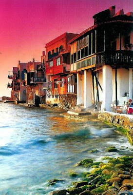
Mykonos & Athens - Greece

One of the last time i traded with Manuela, she sent me 2 greek cards. The 1st one is from Mykonos and the other from Athens.  

 Summer Dream Edition - Photo by L. Hapsis
I had to do some research to make sure this card really was from Mykonos. And, yes it is.
These lovely house are located in Little Venice neighborhood.
Little Venice is famous for its picturesque medieval two and three storey houses, which stand like a wall above the sea, and their colourful wooden balconies. Little Venice is one of the most beautiful and romantic places in the whole of Mykonos and offers a fantastic sunset.

No research was required to identify the place on this card.
The world famous Acropolis of Athens is an ancient citadel located on a high rocky outcrop above the city of Athens and containing the remains of several ancient buildings of great architectural and historic significance, the most famous being the Parthenon. Although there are many other acropoleis in Greece, the significance of the Acropolis of Athens is such that it is commonly known as "The Acropolis" without qualification. - in: wikipedia

Wednesday, April 24, 2013

Favorites from Bulgaria

Two favorites from Bulgaria sent by Lilia.

 UNICART
Vidin is a port town on the southern bank of the Danube in northwestern Bulgaria.
Vidin boasts two well-preserved medieval fortresses, one of them is Baba Vida.
Baba Vida was raised upon the remains of the ancient town of Bononia. The construction of the medieval castle began during the second half of the 10th century, but during the Second Bulgarian Empire (the end of the 12th – 14th century) the basic construction was performed. The last Bulgarian king before the falling of Bulgaria under the Ottoman dominion, Ivan Sratsimir (1324– 1397) had lived in the fortress.
According to a legend, Vida had been the eldest daughter of a wealthy Bulgarian boyar. Due to the unsuccessful marriages of her sisters – Kula and Gamza, Vida rejected all of the proposals for marriage, built the castle and remained in it for the rest of her life.
The first excavations in the fortress from 1956 to 1962 uncovered remains of the Roman, Byzantine, early Bulgarian, late Bulgarian and Ottoman age.
Baba Vida was opened to visitors in 1958 and a museum was arranged in the fortress.
In 1964 the medieval castle was declared a monument of culture, having national significance.
The fortress is surrounded by a moat, which was sometimes filled with water from the river Danube, and the bridge was mobile. Baba Vida had nine corner and intermediate towers with the walls and the towers ending with loop-holes.
The grounds of a chapel from the 13th-14th century were found during excavations in the fortress.
At the moment two of the towers are accessible for visiting. There is a prison in the fortress, in which torture devices can be seen. The figures of an executioner and a prisoner with which the tourists often take pictures are attractive. Cannons and gallows are exposed on one of the terraces.
Baba Vida is among the most preserved medieval fortification constructions in Bulgaria, which is why it is not accidentally often chosen as a set for shooting movies. The summer theatre of Vidin where concerts, theater performances and other shows are conducted, is also situated in the fortress. - in:  http://bulgariatravel.org/en/object/21/Krepost_Baba_Vida

UNICART
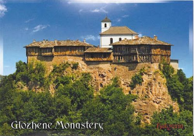
The Monastery “St. George the Victorious” is situated at a distance of about 17 km from the village of Glozhene, where its name comes from.
It is believed that in the 13th century the Kiev Prince Glozh, who obtained the region as a gift from Tsar Ivan Asen II (ruling from 1218 to 1241), constructed the monastery St. Transfiguration of Jesus in the region, as well as a small fortress. The Monastery existed by the 17th century, and in the beginning of the 18th century the monks built a new monastery, dedicated to St. George the Victorious, on the high rock, in order to protect it from the raids of the Ottomans. For some time the two monasteries existed simultaneously, being connected by a tunnel in the rocks.
In the end of the 18th and the beginning of the 19th century, the Monastery St. George the Victorious developed education activity – near the village of Malak Izvor, as well as in the town of Lovech the monks established a convent and a monastery school.
The monk residents were constructed in 1858 on the place of old buildings. The initial monastery church was demolished by the earthquakes in 1904 and 1913. The new church of the monastery was constructed in 1931, and the wood-carved iconostasis saved from the demolished old temple was moved inside it.
The Glozhene Monastery was declared an architectural, constructional and historical monument by Protocol of the National Cultural Monuments Council of 19 June 2006. The monastery is an active male monastery.  - in: http://bulgariatravel.org/en/object/57/Glojenski_manastir

PL-686869 & CZ-278623

I've posted the polish card last friday but i'm posting it now with a czech card because both cards are from the Giant Mountains, a mountain range located in the north of the Czech Republic and the south-west of Poland, part of the Sudetes mountain system. The Czech-Polish border, which divides the historic regions of Bohemia and Silesia, runs along the main ridge.
On both sides of the border, large areas of the mountains are designated national parks (the Krkonoše National Park in the Czech Republic and the Karkonosze National Park in Poland), and these together constitute a cross-border biosphere reserve under the UNESCO Man and the Biosphere Programme. The River Elbe springs within the Krkonoše. The range has a number of major ski resorts, and is a popular destination for tourists engaging in downhill and cross-country skiing, hiking, cycling and other activities. - in: wikipedia

PL-686869, sent by Beata.
The Karkonosze National Park in southwestern Poland is located in Lower Silesian Voivodeship, in the highest part of the Sudetes. It was established in 1959.
The building we can see on the card is the Samotnia Refuge, a wooden pearl of Lower Silesian mountain refuges. The refuge is situated on the banks of the Little Pond at the height of 1195 and built in the style of mountain huts. It is the oldest shelter in the Polish mountains.
 
Photo by Jiri Dvorak, Janusz Moniatowicz
CZ-278623, sent by "staple".
Krkonoše National Park is located in the Liberec and Hradec Králové regions of the Czech Republic.
The Krkonoše National Park is one of the most valuable natural areas in all of Central Europe. The highest Czech mountain range, it is a unique mosaic of ecosystems which have remained here as a reminder of the ancient glacial past. This is a wonderful landscape with high mountain slopes, flat ridges, alpine meadows with colourful wildflowers, and mysterious moorlands, all presided over by the “Czech Matterhorn” – the highest Czech mountain. - in: http://www.czechtourism.com/c/krkonose-national-park/
Because of its uniqueness this area was classified as National Park in 1963.

Friday, April 19, 2013

Bezděz Castle - Czech Republic

The royal castle of Bezděz was one of the most important Gothic castles in the Czech lands until its destruction in the Thirty Years' War.


Photo by V. Fukal
Bezděz, once a royal castle, is one of the most significant Gothic monuments in the country. Visitors can admire the royal palace with a unique chapel and abundant Gothic architectonic details, the burgrave's palace and other parts of the castle. The Grand Tower with a knights' hall on the top floor that offers spectacular views of the surroundings is open to the public as well.
Bezděz Castle was built in the 13th century as a royal castle. It is an important part of Czech history. The castle is considered the most sophisticated type of castle ever. It was difficult to access so any extensive renovation was nearly impossible. Bezděz Castle is situated at the top of the hill of Bezděz (604 m above sea level). Its 35 m tall tower offers superb panoramic views of distant surroundings. - in:
http://www.liberecky-kraj.cz/dr-en/1228-bezdez-castle.html

CZ-260915

An official from Czech Republic showing St. Wenceslaus Church in Ovčáry (nowadays part of Slaný town).  Slaný is located in the Central Bohemian Region of the Czech Republic, located about 25 km northwest of Prague.

Photo by Pavel Vychodil
CZ-260915, sent by Alena.
The church is first mentioned in documents in 1465.
The town of Slaný initiated overall refurbishment of the dilapidated building in 2003.

Wednesday, April 17, 2013

Gołuchów Castle - Poland

One last card from Poland, also sent by Emerich. A new castle in my collection.

Photo by Dariusz Krakowiak
The building represents an amazingly rich composition of various colors, shapes and moods. Built in 1560, the castle obeys the conventions of French Renaissance. Although its beginnings can be traced all the way back to Rafał Leszczynski, the castle was significantly extended at the threshold of the 17th century by Wacław Leszczynski.
Yet, its heyday came in between 1872 and1885 with Izabela Działynska, who redecorated it in the spirit of French Renaissance castles.
The decoration of the building became the passion of her life. Specifically, Gołuchów was to host her numerous collections of various exhibits, hitherto kept in Paris. At the same time, Czartoryska did her best to make it a Paradise on Earth, outlining its idyllic character.
The castle is surrounded by a heritage park - arboretum and it borders on a wisent pen, the only one in Wielkopolska. - in: http://travelpoland.info/greater-poland/castle-in-goluchow.html

Licheń & Gorzów Wielkopolski

Two very different religious buildings in Poland, the Basilica of Our Lady of Licheń and St. Mary's Cathedral in Gorzów Wielkopolski.
Both cards have been sent by Emerich.

 Photo by Dariusz Krakowiak
The Basilica of Our Lady of Licheń is a Roman Catholic church located in the village of Licheń Stary near Konin in the Greater Poland Voivodeship in Poland. It was designed by Barbara Bielecka and built between 1994 and 2004. The construction was funded by pilgrims' donations.
With the nave 120 meters long and 77 meters wide, with a central dome 98 meters high, and with a tower 141.5 metres tall, it is Poland's largest church and one of the largest churches in the world. The church is dedicated to Our Lady of Sorrows, Queen of Poland whose icon, perhaps dating back to the 18th century, is displayed in the basilica's main altar. It is one of Poland's principal pilgrimage sites.
Pope John Paul II blessed the Basilica in 1999. - in: wikipedia

Photo by Dariusz Krakowiak
Gorzów Wielkopolski is a city in western Poland, on the Warta river. It is the biggest city in the Lubusz Voivodeship.
Although the centre of Gorzów was heavily damaged during the Second World War, there are still many notable tourist attractions in the city. The largest of these is the Gothic, red-brick Gorzów Cathedral of the Virgin Mary, dating from the end of the 1200s, situated on the old market square. - in: wikipedia

Tuesday, April 16, 2013

Bones' Chapels

This post is not for the faint of heart.
These are two cards from Poland and Portugal with unique constructions, bones' chapels. I've visited the portuguese Bones' Chapel 4 years ago. That's something..... different!!

© GRAFIX
Skull Chapel (Kaplica Czaszek) in Czermna is a chapel located in Kudowa-Zdrój, Lower Silesian Voivodeship.
The chapel was built in 1776 by the local parish priest Wacław Tomaszek. It is the mass grave of people who died during the Thirty Years’ War (1618–1648), three Silesian Wars (1740–1763), as well as of people who died because of cholera epidemics and hunger.
Together with J. Schmidt and J. Langer, Tomaszek collected the casualties’ bones and put them in the chapel. Walls of this small, baroque church are filled with three thousand skulls, and there are also bones of another 21 thousand people interred in the basement. The skulls of people who built the chapel are placed in the centre of the building and on the altar.
It is the only such monument in Poland, and one of three in Europe. - in: wikipedia

EDIG
The Chapel of Bones (Capela dos Ossos) is one of the best known monuments in Évora, Portugal. It is a small interior chapel located next to the entrance of the Church of St. Francis. The Chapel gets its name because the interior walls are covered and decorated with human skulls and bones.
The Chapel of Bones is entered through a large arch bearing a painted rhyme reminding visitors of their own mortality: Nós ossos que aqui estamos, pelos vossos esperamos: "Our bones that are here wait for yours!"
Inside, human bones and skulls completely cover the chapel's walls and pillars - the number of skeletons has been estimated at 5,000. Legend has it the bones come from soldiers of a major battle or plague victims, but in reality they are people from all walks of life who were buried in Evora's medieval cemeteries.
Interestingly, the bones of the monks who assembled the chapel are not on display - they are kept in a small white coffin in the chapel. In addition to all the bones, there are two full corpses hanging high on a wall. Their identities are unknown, but there are plenty of legends: one popular story says they are an adulterous man and his infant son, cursed by his jealous wife.
At one end of the chapel, an altar with a crucifix reminds visitors of the way to overcome death. The rib-vaulted ceiling of the chapel continues the theme, painted with small scenes accompanied by Latin phrases such as "I leave, but I don't die," "I die in the light," and "The day that I die is better than the day that I was born." - in: http://www.sacred-destinations.com/portugal/evora-capela-dos-ossos-chapel-of-bones

Saturday, April 13, 2013

Kazimierz Dolny & Sandomierz

Polish cards from Kazimierz Dolny and Sandomierz, both sent by Emerich.

 Photo by Dariusz Krakowiak
Kazimierz Dolny is a small town in Central Poland.
This is the Celej House also know as St. Bartholomew house due to the figure of the saint on the right-facing façade.
It was probably buil in the 16th century and its owner was a rich merchant and town concillor Bartlomiej Celej.
The richly decorated façade has all the caractheristic forms used by the sculptors and builders of the time. There are animals, plants and querubs. On this particular façade there is Jesus Christ as the Savior of the world, and St. Mary as Queen of Heaven. On the left there's St. John the Baptist with a Cross and St, Bartholomew with a knife.
After World War II, Karol Sicinski had his architectural studio here. It was there where the reconstruction of Kazimierz Dolny was planned and prepared.
In 1964 the house became the seat of Regional Museum, which in 1972 became Kazimierz Dolny Museum and in 1987 was given the name of Nadwislanskie Museum. Nowadays, the exhibits works of artists who were inspired by Kazimierz Dolny. - in: http://www.kazimierzdolny.eu/monuments/108/

Photo by Dariuz Krakowiak
Sandomierz is a town in south-eastern Poland, known for its Old Town, a major tourist attraction. This beautiful building is the town hall, built in the 14th century. It initially had a form of tower. Due to a rebuilding in the 15th C., the structure got the shape of a lengthened rectangle. A century later, it got a high attic, decking the whole roof, and in the beginning of the 17th C. a tower was added on the western side.
The building went through several fires, mainly in 1623 and 1757, yet luckily it is made of brick, so the construction has not been completely damaged.
Moreover, a spacious cellar has been lately discovered under the building. The room could have been used as prison where the accused were tortured, as there are hooks and rings attached to the walls. Yet, these are not only remarkable elements of this object. In another part of the building, there is a residence of the Regional Museum with historic and artistic exhibitions.
The Town Hall’s interiors are also noteworthy because of the late-Renaissance, neo-Renaissance and neo-Baroque furniture. The historic department of the museum covers the ground floor of the building, while on the first floor there is a wedding hall and the rooms of the City Council. In the basement one can find “Lapidarium” (“The Lapidary”), a club of the Sandomierz Cultural Society. - in: http://www.wrota-swietokrzyskie.pl/608

Romanian Unesco WHS

The last time i've got a romanian card was more than a year ago... but after a year without any card from there, i've got these from the last 2 Unesco Whs i was missing from Romania, the Dacian Fortresses of the Orastie Mountains and Horezu Monastery. The 1st card was sent by Fabienne and the 2nd by Manu.

 Built in the 1st centuries B.C. and A.D. under Dacian rule, these fortresses show an unusual fusion of military and religious architectural techniques and concepts from the classical world and the late European Iron Age. The six defensive works, the nucleus of the Dacian Kingdom, were conquered by the Romans at the beginning of the 2nd century A.D.; their extensive and well-preserved remains stand in spectacular natural surroundings and give a dramatic picture of a vigorous and innovative civilization. - in: http://whc.unesco.org/en/list/906

Photo by C. P. C. S.
Founded in 1690 by Prince Constantine Brancovan, the monastery of Horezu, in Walachia, is a masterpiece of the 'Brancovan' style. It is known for its architectural purity and balance, the richness of its sculptural detail, the treatment of its religious compositions, its votive portraits and its painted decorative works. The school of mural and icon painting established at the monastery in the 18th century was famous throughout the Balkan region. - in: http://whc.unesco.org/en/list/597

Thursday, April 11, 2013

Ukrainian Carpathians

This card, sent by Marina is so, so beautiful. I'd love to be there. Yes, I'm crazy about snow, it should snow like this here. Well, last winter was kinda good, it snowed a couple of times but after 2 days the snow was all gone. I miss the snow storms from the past.

The card shows a traditional wooden hut on Khormiakiv shieling, mountain range Gorgany, in Western Ukraine in Outer Eastern Carpathians.

Lufa Photos
The Carpathian Mountains or Carpathians are a range of mountains forming an arc roughly 1,500 km (932 mi) long across Central and Eastern Europe, making them the second-longest mountain range in Europe.
The Carpathians consist of a chain of mountain ranges that stretch in an arc from the Czech Republic (3%) in the northwest through Slovakia (17%), Poland (10%), Hungary (4%) and Ukraine (11%) to Romania (53%) in the east and on to the Iron Gates on the River Danube between Romania and Serbia (2%) in the south.
The Carpathians are usually divided into three major parts: the Western Carpathians (Czech Republic, Poland, Slovakia), the Central Carpathians (southeastern Poland, eastern Slovakia, Ukraine, Romania), and the Eastern Carpathians (Romania, Serbia). - in: wikipedia

UA-450939, UA-484165 & UA-465690

Officials from Ukraine.

 UA-450939, sent by Elia.
This beautiful cathedral is located in Lugansk, a city in southeastern Ukraine
St. Vladimir's Cathedral is a unique structure. Its construction began in 1993 and it was consacrated in 2006.
The cathedral is one of the biggest religious building in southeast Ukraine.

UA-484165, sent by Liv.
These are a few ukrainian temples in different cities.
Clockwise direction: Eletsky monastery cathedral in Chernihiv; St. Michael's Golden-Domed Monastery in Kiev;  Feodosiya's fortress and church; Mhar Monastery; wooden orthodox church of the Holy Spirit in Potelich; the Holy Trinity Church within the fortified monastery in Mezhyrich; Church of St John the Baptist in Kerch; Carmelite convent in Berdychiv; Korec's monastery; Bakhchisaray Cave Monastery; Molchansky Monastery in Putyvl; St. George's Cathedral in Lviv and in the middle Holy Dormition Pochaiv Monastery.

UA-465690, sent by Anastasia.
Finally, my 2nd card from Sevastopol, showing some of the city's monuments, such as the Monument to Sunken Ships. The installation of the monument was timed to match the 50th anniversary of the first defense of Sevastopol, when Russian sailing ships were sunk for the sake of saving Sevastopol.

RU-1467882

Another Belarus card but sent as an official from Russia. The card depicts three churches in Brest.

RU-1467882, sent by Vika.
These are the St. Nicholas Community Church; St. Simon Orthodox Cathedral and St. Nicholas Garrison Cathedral.

Wednesday, April 10, 2013

Cathedral of Saint Virgin Mary - Belarus

This card was sent by Kasia, who contacted me via the official postcrossing site.

This is a Roman Catholic baroque cathedral in Minsk.
The cathedral was built in 1710 as a church of the Jesuit monastery. In 1793, after Russia's taking over Belarus, the Jesuit order was banned and the church got a local status. Soon, after creation of the Minsk diocese, the church became the local cathedral.
The Cathedral was heavily damaged in a fire in 1797, but was later fully renewed. 
In 1920, Bishop Lazinski was arrested by Soviet authorities, the cathedral was closed down in 1934.
During the Second World War, the Germans allowed the cathedral to function again, but after the war it was again closed down by the Soviets. In 1951, the cathedral's bell towers were intentionally destroyed by Soviet artillery and the building itself was given to the Spartak sports society.
In the beginning of the 1990s, religious services started again. In 1993, the building was given back to the Roman Catholics; by 1997 it was renewed. - in: wikipedia

Tuesday, April 9, 2013

Struve Geodetic Arc - Russia

To have all the russian Unesco sites i only needed a card of one of the two russian Struve Geodetic Arc points and i got it thanks to Galina. One more completed country.
This is a card of the Gogland or Hogland island, in the Gulf of Finland in the eastern Baltic Sea, about 180 km west of Saint Petersburg and 35 km from the coast of Finland.

Since 1826, the hill Mäkiinpäällys has two of the points in the Struve Geodetic Arc.
The gentleman on the card is Friedrich Georg Wilhelm von Struve, the german astronomer who initiated the Struve Geodetic Arc.

Sunday, April 7, 2013

Russian nature

These lovely nature cards were also sent by Galina.

I can't identify the location of this image but there's somewhere in northern Russia and it's seems a perfect place for a fox to live.

Photo by Igor Shpilenok
I'm not a fox expert but i think this is a red fox. She lives in the Kronotsky Nature Reserve, which became a UNESCO World Heritage Site, in 1996, as part of the “Volcanoes of Kamchatka”.
This is a nature area reserved for the study of natural sciences in the remote Russian Far East, on the coast of the Kamchatka Peninsula.

"Malye Korely" Open-Air Museum of Wooden Architecture

A few months ago Galina proposed me a trade and we swapped 7 or 8 cards.
I really like wooden churches, that's something we don't have here. She had a few cards of the "Malye Korely" Open-Air Museum of Wooden Architecture and i picked this card.
This museum is located in Malye Korely, a village in Primorsky District of Arkhangelsk Oblast, in the north of Russia. The main sight of the village is this open-air museum, featuring the traditional wooden architecture of Arkhangelsk area.

The museum was created on July 17, 1964. Traditional wooden architecture has been recognized at the time one of the most characteristic features of Russian Norths, and some of the buildings, churches, chapels, and peasant houses, scattered all over the Arkhangelsk Oblast, were put under state protection. The goal of the creation of the museum was to save the most outstanding wooden monuments, placing them under protection on the premises of the museum. - in: wikipedia

And this is the St. George Church (1672) from the village of Vershiny.

RU-1419382 & RU-1549813

A church and a lighthouse from Russia.

 RU-1419382, sent by Lera.
This is the Church of the Nativity of the Blessed Virgin Mary in Kazan, better known as the St. Paraskeva Church.
It was built in 1726-1728 in russian baroque style.

RU-1549813, sent by Liliy.
This is the "Fish Village" in Kaliningrad, a commercial area made up of small old-fashioned buildings, souvenir shops and stalls, smokehouses, wine cellars, fish restaurants, bars, cafes, discos, business premises, company offices, hotels and museums. The most recognizable building of “Fish Village” is a Viewing Tower “Lighthouse”.
You may enjoy a wonderful view over the river and the island of Kant sitting with a cup of coffee in a cozy cafe “Coffee Lounge”, located on the third floor of the tower.
In addition, there is an art gallery.
The tower’s height is 31 meter, 133 steps. 

Friday, April 5, 2013

Finnish official cards

I've been getting a lot of church cards from Finland, most of my last officials from there are churches. 

 Photographed and Published by Janne harala Tmi, Lahti
 FI-1666941, sent by Silve.
Enough of Helsinki's churches, this one is Michael's Church in Turku.
The church is situated in central Turku. It's named after Archangel Michael and was finished in 1905. It dominates the western skyline of the city of Turku was designed by Professor Lars Sonck and is one of the most popular wedding churches in Turku being able to seat 1,800 people. When Sonck won the competition for the church in 1894, he was only a 23-year old architectural student. Michael's Church is older than Michael's parish. The parish only dates back to 1921. - in: wikipedia
 
Photo by Kalevi Asplund
FI-1710722, sent by Sansku.
Kittilä is located in northern Finland north of the Arctic Circle within the area of the former Lappi province.
The lovely Kittilä church in designed by C.L. Engel, the architect of the cathedral in Helsinki, and completed in 1831. During the Lapland War it was the only building in the town not burned by the retreating German army.